BS & FS in Surveying | Leveling in Surveying
Introduction
In the realm of land surveying, precision and accuracy are paramount. Surveyors employ various techniques to measure elevations and distances accurately. Two of the most fundamental methods are Backsight (BS) and Foresight (FS) in leveling, which play a pivotal role in achieving reliable survey data.
Understanding Leveling in Surveying
What is Leveling?
Leveling is a crucial aspect of land surveying that involves determining the relative heights or elevations of different points on the Earth's surface. It is indispensable for creating topographical maps, assessing construction sites, and ensuring precise measurements.
The Basics of Leveling
Leveling is based on the fundamental principle that gravity acts vertically downward, allowing surveyors to establish a horizontal reference plane. The process involves the use of leveling instruments, such as the level, theodolite, or total station, to measure height differences between points.
Backsight and Foresight in Surveying
What are Backsight (BS) and Foresight (FS)?
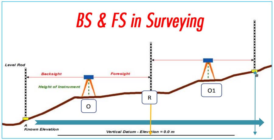
Backsight (BS) and Foresight (FS) are two critical components of the leveling process. BS refers to the measurement taken on a previously established point with a known elevation, while FS pertains to the measurement on the point of interest whose elevation we want to determine.
- Importance of Backsight: BS acts as a reference point with a known elevation, providing a reliable starting point for the leveling process. It ensures that the subsequent measurements are accurate and consistent.
- Role of Foresight: FS, on the other hand, is the measurement taken on the target point whose elevation is to be determined. It is the key element in leveling, as it allows surveyors to calculate the height difference between the BS and FS points accurately.
The Levelling Process
- Step-by-Step Leveling Procedure
- Setup: Begin by setting up the leveling instrument at a stable location.
- Backsight Reading: Take a reading on a known point, recording the elevation.
- Foresight Reading: Move the instrument to the point of interest and take a reading.
- Calculations: Calculate the height difference (rise or fall) between the BS and FS points.
- Adjustment: Make any necessary adjustments to ensure accuracy.
- Repeat: Repeat the process as needed to cover the entire survey area.
Applications of BS and FS in Surveying
Where are BS and FS Used?
BS and FS are widely used in various surveying applications, including:
- Construction: Ensuring precise elevation measurements for construction projects.
- Topographic Mapping: Creating accurate topographic maps.
- Land Development: Assessing land for development purposes.
- Floodplain Management: Determining elevations for flood risk assessment.
- Infrastructure Design: Designing roads, bridges, and drainage systems.
Conclusion
In the realm of surveying, achieving accuracy is paramount, and Backsight (BS) and Foresight (FS) play a pivotal role in this pursuit. These fundamental components of leveling allow surveyors to obtain precise elevation measurements, making them indispensable in various applications such as construction, mapping, and land development. By understanding the principles and procedures behind BS and FS, surveyors can continue to contribute to the development and management of our built environment.
FAQs
What is the main purpose of leveling in surveying?
Leveling in surveying is primarily used to determine the relative heights or elevations of different points on the Earth's surface. It is crucial for creating accurate maps, assessing construction sites, and ensuring precise measurements.
Why is Backsight (BS) important in leveling?
Backsight (BS) serves as a reference point with a known elevation, ensuring that subsequent measurements in the leveling process are accurate and consistent.
What is the role of Foresight (FS) in surveying?
Foresight (FS) is essential in leveling as it involves taking measurements on the point of interest whose elevation is to be determined. It allows surveyors to calculate the height difference between the BS and FS points accurately.
Where are Backsight (BS) and Foresight (FS) commonly used in surveying?
BS and FS are used in various surveying applications, including construction, topographic mapping, land development, floodplain management, and infrastructure design.
How can surveyors ensure the accuracy of their leveling measurements?
Surveyors can ensure accuracy by carefully following the leveling procedure, making necessary instrument adjustments, and cross-checking measurements when necessary.