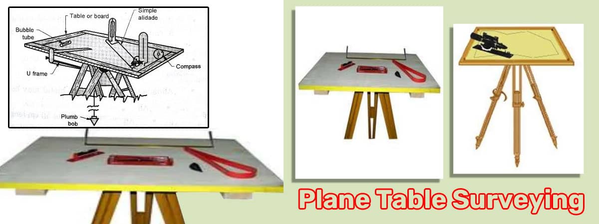
Plane Table Survey Instruments used in construction projects

Introduction
In the world of construction and civil engineering, accuracy and precision are of utmost importance. The use of advanced surveying instruments has revolutionized the way construction projects are planned and executed. One such essential tool is the plane table survey instrument.
What is a Plane Table Survey Instrument?
A plane table survey instrument is a fundamental tool used in land surveying and civil engineering. It consists of a flat table with a mounted alidade or telescopic sight. The table is precisely leveled and can rotate horizontally. Surveyors use this instrument to measure the relative position of points and map the area directly on the table itself.
Components of a Plane Table
A typical plane table setup includes the following components:
- Flat Table: The main surface where the surveyor works and makes measurements.
- Alidade: A telescopic sight or a rule that is mounted on the table. It helps in sighting distant objects.
- Spirit Level: To ensure the table is perfectly leveled.
- Tripod Stand: Supports the plane table and keeps it steady during measurements.
- Plumb Bob: Ensures the vertical alignment of the table.
Setting Up a Plane Table Survey
Before beginning the survey, the plane table must be correctly set up. Here's a step-by-step guide to setting up the instrument:
- Choose a stable and flat location for the survey.
- Place the plane table on the tripod stand and secure it.
- Use the spirit level to ensure the table is perfectly level.
- Suspend the plumb bob to achieve the vertical alignment.
- Orient the table to the true north using a compass.
Orienting the Plane Table
Orienting the plane table is crucial for accurate surveying. The orientation can be done using a compass or by sighting known landmarks. The table is then adjusted to align with the north-south meridian.
Types of Plane Table Surveys
There are three common methods of conducting plane table surveys:
- Radiation Method: In this method, the surveyor selects a reference point and measures angles and distances from that point to other points of interest.
- Intersection Method: The intersection method involves fixing the plane table at a station and sighting objects from two or more locations to determine their positions.
- Traversing Method: In the traversing method, the surveyor moves from one point to another, measuring angles and distances along the way to create a complete survey.
Advantages of Plane Table Surveys
- Provides accurate and detailed mapping of the area. Enables on-site data collection and immediate analysis.
- Suitable for small to medium-sized projects.
- Requires minimal mathematical calculations compared to other surveying methods.
Limitations of Plane Table Surveys
- Time-consuming for large-scale projects.
- Not suitable for areas with obstructed views or dense vegetation.
- Less precise than modern electronic surveying methods.
Modern Technological Advancements in Plane Table Surveys
With technological advancements, plane table surveys have seen significant improvements. Digital plane tables equipped with electronic theodolites and distance measuring instruments have enhanced their accuracy and efficiency.
Integration with GPS Technology
Modern plane table survey instruments can be integrated with GPS technology, allowing surveyors to geotag their data and create highly accurate geospatial maps.
Applications in Construction Projects
Plane table surveys find extensive applications in construction projects:
- Determining property boundaries and land divisions
- Creating topographic maps for site planning.
- Laying out roads, buildings, and other structures.
- Monitoring construction progress and deformation analysis.
Best Practices for Using a Plane Table
To ensure the best results from a plane table survey, consider the following best practices:
- Calibrate the instruments regularly.
- Use a sturdy and stable tripod stand.
- Double-check measurements for accuracy.
Tips for Accurate Measurements
- Take measurements in good lighting conditions.
- Keep the alidade lens clean and free from obstructions.
- Minimize human errors by training surveyors effectively.
Ensuring Data Integrity and Reliability
Maintaining data integrity is crucial for the success of any surveying project. Regular backups and quality checks help ensure the reliability of the data collected.
Safety Measures
Surveyors should take necessary safety precautions, especially when working in hazardous construction sites or remote locations.
Conclusion
Plane table survey instruments have played a vital role in construction and land surveying for centuries. While they have evolved with technological advancements, their significance remains undeniable. These instruments provide accurate and detailed data, enabling engineers and construction professionals to make informed decisions and execute projects efficiently.
FAQs
Are plane table surveys still relevant in the digital age?
Yes, despite modern electronic surveying methods, plane table surveys remain relevant for specific applications and small to medium-sized projects.
What is the primary advantage of using a plane table?
The primary advantage is the ability to map and analyze the area directly on the table, reducing the need for extensive calculations.
Can a plane table be used in rugged terrains?
Yes, with proper setup and precautions, a plane table can be used in rugged terrains, although GPS integration might be more suitable in such cases.
How often should a plane table be calibrated?
Regular calibration is essential, and it should be done at least once every few months or when there are any signs of inaccurate readings.
What are the limitations of plane table surveys?
Plane table surveys can be time-consuming for large-scale projects and might not provide the same level of precision as modern electronic methods.
