Leveling and its Different Methods

A leveling technique generally achieves this relative elevation of points on the ground as a reference datum. In most cases, it is an independent procedure that uses to fix the plan metric coordinates.
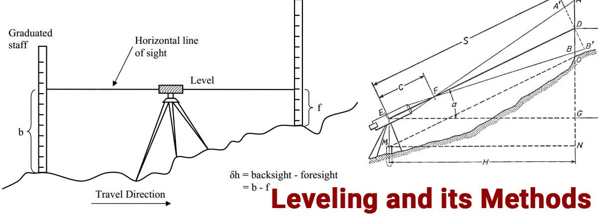
The process of leveling involves measuring a vertical distance on a horizontal line of sight. As a result, the vertical measurements can take with a graduated staff. The horizontal measurements can take with an instrument that will provide a line of sight.
Some Key Terms in Leveling
Level Surface
The level surface is set perpendicular to the direction of gravity at each point and corresponds to a curved surface. An accurate level surface, for example, is still water. Moreover, level surfaces are those analogous to the spherical surface of the earth's core.
Level Line
Whenever a line crosses a level surface at a particular point it is said to be tangential. In other words, the plumb line is normal at every point.
Horizontal Plane
By tangential to a level surface at a point, we mean a horizontal plane. The plumb line is perpendicular to it via the point.
Horizontal line
A level line at a point is tangential to the level line. Also, a level line at a point is orthogonal to the plumb line.
Vertical Line
A point on the level line is parallel to this line. As a result, the plumb line determines this vertical line.
Vertical Angle
The vertical angle is the angle formed by two intersecting lines in a vertical plane. However, it is more common for one of these lines to be horizontal.
Datum
The term datum refers to elevated surfaces. Around the world, the mean sea level is a useful datum, and elevation defines as the difference between it. When the only need is comparative elevation, then it would be more appropriate to use another datum.
Mean Sea Level
In all phases of the tides, it represents the average height of the sea. An hourly tide height obtains at a particular location by averaging its hourly height over 19 years.
Elevation
In geology, elevation refers to how much a point lies above or below an arbitrarily anticipated level surface. The difference in elevation between two points on a two-level surface corresponds to the vertical distance between them.
Bench mark
There is an elevation for an anticipated datum that is a comparatively permanent reference point. A leveling point serves as either a starting point or a checkpoint.

Methods of Leveling
Simple leveling
It is a simple method of leveling that measures the elevation between two points. It then views through a leveling instrument through leveling rods. If there are no obstacles between the points, this can only happen when they are close to each other.
Precise Leveling
As with differential leveling, precise leveling requires greater precision. Observation is necessary to achieve such high precision. We can achieve an accuracy of 1mm per km precisely.
Barometric Leveling
Using a barometer, you can determine the atmospheric pressure at any height. The vertical difference between the two points is calculated based on the atmospheric pressure observed at two different places. That is a rough estimate, and that is the reason this method uses less.
Reciprocal Leveling
The reciprocal leveling process carries out if the leveling instrument cannot locate between the inter-visible points. For reciprocal leveling in ponds and rivers, the instrument is set closer to the first station and sighted to the second station.
Indirect Leveling (Trigonometric Leveling)
Another name for this method is indirect leveling. Through the observation of horizontal distances and vertical angles, trigonometric leveling determines the elevation or differences between the points in the field. The trigonometric leveling method uses to calculate the height of a point based on angles and horizontal distances.
Differential Leveling
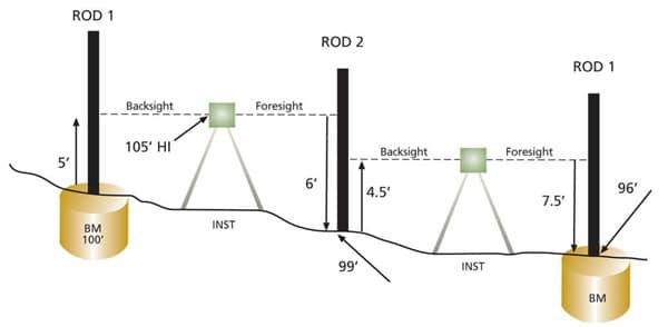
Differential leveling applies when there is a greater distance between two points. An instrument shifts from station to station to determine the elevation of a point by establishing a series of inter-stations. However, the difference between the two original points is calculated.
Fly Leveling
Whenever the benchmark is in a very remote location from the workstation, then fly leveling conducts. An example of this is when the work station is placed based on an original benchmark, and a temporary benchmark is placed. The temporary benchmark uses to determine approximate levels.
Stadia Leveling
Chaining is a common method for measuring horizontal distances. Differential leveling is a common method for measuring vertical distances. The results of both methods are accurate. However, chaining on rough grounds does not provide very accurate results. Tachometers are the best choice when the ground is rough, and a higher number of measurements at a faster rate are acceptable.
