Advanced Methods of Surveying: A Comprehensive Guide for the 21st Century

Surveying has evolved beyond traditional techniques, incorporating state-of-the-art technologies and methodologies to deliver higher precision, efficiency, and data integration.
1. Global Navigation Satellite System (GNSS) Surveying

GNSS surveying - which includes GPS, GLONASS, Galileo, and BeiDou systems - is the cornerstone of modern geospatial measurement.
- Real-Time Kinematic (RTK) GNSS enables centimeter-level accuracy by using a base station and a rover, transmitting real-time correction data.
- Post-Processed Kinematic (PPK) involves processing GNSS data after collection to achieve high accuracy, particularly useful in areas with limited connectivity.
- Static GNSS Surveys are ideal for establishing control networks with high precision over long durations.
These methods drastically reduce setup time and allow for georeferenced data acquisition in real-time across vast areas.
2. Total Station and Robotic Total Station (RTS)

Total Stations combine electronic distance measurement (EDM) with angular measurements to provide precise 3D point data. The Robotic Total Station (RTS) automates tracking and measurement, operated by a single person.
- Auto-tracking features increase productivity and reduce human error.
- Reflectorless technology enables data capture from surfaces without the need for a prism.
RTS systems are widely used in construction layout, topographic surveys, and deformation monitoring due to their high accuracy and automation.
3. 3D Laser Scanning (LiDAR Technology)
LiDAR (Light Detection and Ranging) is one of the most significant advancements in surveying. It uses pulsed laser beams to capture millions of measurements per second.
- Terrestrial Laser Scanning (TLS) is ideal for building interiors, tunnels, and complex structures.
- Mobile LiDAR integrates scanners on vehicles for corridor mapping such as roads and railways.
- Aerial LiDAR mounted on drones or aircraft is used for large-scale topography, forestry, and flood modeling.
LiDAR offers dense point clouds and highly detailed 3D models, facilitating analysis for urban planning, BIM (Building Information Modeling), and archaeological studies.
4. Photogrammetry via Unmanned Aerial Vehicles (UAVs)
Drone surveying has become an indispensable method in modern surveying practices. Using photogrammetry, UAVs capture overlapping images that are processed to generate orthomosaics, digital surface models (DSMs), and 3D reconstructions.
- RTK/PPK drones offer sub-inch level accuracy.
- Flight planning software ensures consistent, repeatable, and optimized aerial routes.
- Applications include agriculture, construction progress tracking, asset inspection, and mining volumetrics.
UAV photogrammetry drastically reduces costs and time for large-scale surveys, especially in hard-to-reach areas.
5. Ground Penetrating Radar (GPR)
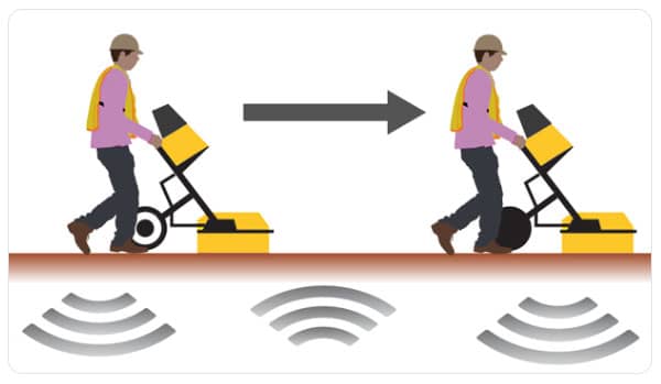
GPR uses radar pulses to image the subsurface, making it invaluable for:
- Utility detection
- Archaeological investigations
- Geotechnical analysis
It identifies the depth and location of underground structures, voids, and anomalies without excavation. GPR data is often used in conjunction with GIS platforms for enhanced spatial visualization.
6. Hydrographic and Bathymetric Surveying
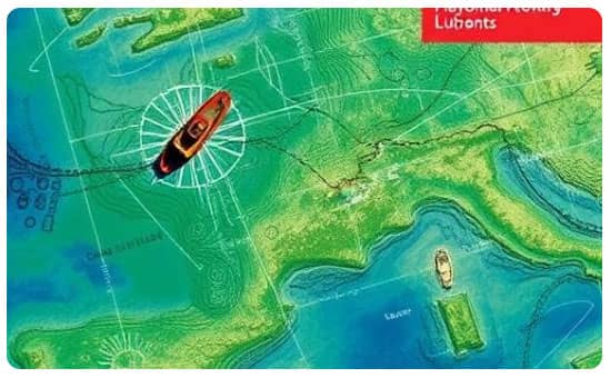
When surveying underwater topography, advanced techniques come into play:
- Single-beam and multi-beam echo sounders (SBES and MBES) collect depth data for water bodies.
- Side-scan sonar creates detailed images of the seafloor.
- Autonomous Surface Vehicles (ASVs) with integrated GNSS and sonar increase efficiency in hazardous or remote environments.
These methods are crucial for harbor maintenance, marine construction, and environmental monitoring.
7. Satellite and Aerial Remote Sensing
Remote sensing uses satellite or aircraft-mounted sensors to gather information about the Earth's surface without direct contact.
- Multispectral and hyperspectral imaging offer data across various wavelengths for vegetation, soil, and mineral analysis.
- Synthetic Aperture Radar (SAR) penetrates clouds and darkness, ideal for all-weather mapping.
Remote sensing supports environmental monitoring, disaster management, and urban planning with macro-level insights.
8. Inertial Measurement Units (IMUs) and INS Integration
IMUs, comprising gyroscopes and accelerometers, measure angular rate and linear acceleration. When combined with GNSS in an Inertial Navigation System (INS), they offer robust positioning solutions.
- Useful in GNSS-denied environments such as tunnels, forests, or urban canyons.
- Provides smooth and continuous positioning, especially in mobile mapping systems.
INS technology is integral in airborne surveys, autonomous vehicles, and marine navigation.
9. Mobile Mapping Systems (MMS)
Mobile Mapping Systems combine LiDAR, GNSS, cameras, and IMUs mounted on moving platforms such as cars, trains, or drones.
- Captures rich geospatial data rapidly across long corridors.
- Ideal for asset inventory, infrastructure documentation, and urban 3D modeling.
- Software integration allows real-time processing and visualization.
MMS dramatically enhances data acquisition for smart city initiatives and transportation infrastructure projects.
10. BIM and GIS Integration in Surveying
Surveying now transcends data collection by integrating with Building Information Modeling (BIM) and Geographic Information Systems (GIS).
- BIM allows collaborative digital representations of physical infrastructure with embedded metadata.
- GIS supports spatial analysis and database management for informed decision-making.
Advanced surveying tools feed directly into BIM and GIS platforms, promoting seamless project lifecycle management from design to demolition.
11. Artificial Intelligence and Machine Learning in Surveying
The application of AI and ML algorithms in surveying enables:
- Automated feature extraction from point clouds and imagery.
- Predictive modeling in land use and environmental monitoring.
- Anomaly detection in structural health monitoring.
These tools accelerate data processing and yield actionable insights with greater accuracy and efficiency.
12. Blockchain for Surveying Records
The emerging integration of blockchain technology offers immutable, verifiable records for:
- Land ownership
- Title management
- Survey authentication
It enhances data integrity, transparency, and traceability, particularly in public land administration systems.
Conclusion
The landscape of surveying has been revolutionized by cutting-edge technologies that enhance accuracy, productivity, and data richness. From aerial drones and mobile mapping to GNSS networks and AI-driven processing, the modern surveyor wields a suite of tools unimaginable just a decade ago. Mastery of these advanced methods is critical for professionals committed to delivering precision-driven, future-ready geospatial solutions.
Please watch the following short video for Advanced Methods of Surveying