What Are the Applications of Drone Surveying in Civil Engineering?

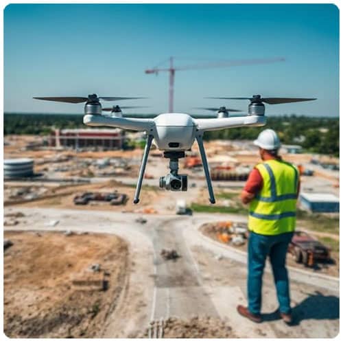
In modern civil engineering, the integration of cutting-edge technology has revolutionized traditional methods. Among these, drone surveying has emerged as one of the most transformative innovations. With high-resolution imaging, real-time data capture, and precise geospatial analytics, drones are now indispensable tools in infrastructure planning, execution, and maintenance.
Introduction to Drone Surveying in Civil Engineering
Drone surveying involves the use of Unmanned Aerial Vehicles (UAVs) equipped with cameras, LiDAR sensors, and GPS modules to collect data from construction or terrain sites. This technology not only enhances the speed and accuracy of surveys but also ensures safety and cost-efficiency, making it a cornerstone in modern civil engineering projects.
1. Topographic Mapping and Land Surveying
One of the most fundamental applications of drones in civil engineering is topographic mapping. Traditional land surveys are time-consuming and require extensive manpower. In contrast, drone-based surveys:
- Deliver high-resolution orthomosaic maps and 3D terrain models
- Capture data over large areas in a fraction of the time
- Detect subtle terrain variations with centimeter-level accuracy
- Enable quick updates for changing site conditions
This data proves essential in planning infrastructure, such as highways, bridges, dams, and urban development projects.
2. Site Analysis and Pre-Construction Planning
Before any physical construction begins, comprehensive site analysis is critical. Drones provide:
- Aerial imagery for visual inspections and site reconnaissance
- Digital Elevation Models (DEMs) and Digital Surface Models (DSMs) for understanding terrain elevation and vegetation
- Insights into soil erosion, water flow, and natural obstructions
These insights guide engineers and planners in making data-driven decisions, reducing the likelihood of costly reworks and delays.
3. Volumetric Calculations and Earthwork Management
Drones revolutionize volume estimation, a key element in earthmoving operations. They allow engineers to:
- Accurately measure stockpiles of materials such as sand, gravel, or excavated earth
- Monitor cut and fill volumes for roadways, embankments, and foundation excavation
- Automate volume reports through photogrammetry and 3D point cloud generation
This data supports real-time project tracking, material cost estimation, and resource optimization.
4. Construction Progress Monitoring
Maintaining a consistent check on project development is vital. Drones enable:
- Regular aerial documentation of site progress
- Time-lapse videos for stakeholder reporting
- Comparison of as-built vs. as-designed models
- Real-time detection of deviations and anomalies
Progress monitoring enhances project transparency, reduces downtime, and ensures adherence to deadlines and budgets.
5. Infrastructure Inspection and Maintenance
Post-construction, civil engineers must assess the health of structures. Drones are ideal for visual and thermal inspections of:
- Bridges and overpasses
- Transmission towers and pipelines
- Dams and retaining walls
- Tunnels and high-rise buildings
They safely access hard-to-reach areas and use infrared cameras to detect cracks, leaks, heat loss, or structural deformities, drastically minimizing manual inspection risks and downtime.
6. Roadway and Highway Design
Road construction projects benefit immensely from drone data, which supports:
- Accurate route alignment
- Road surface condition assessment
- Traffic flow analysis
- Environmental impact assessments
Drones ensure planners get a macro and micro view of the project area, enabling optimized design and alignment decisions.
7. Environmental Impact Assessment
Before civil engineering projects can proceed, regulatory bodies require Environmental Impact Assessments (EIA). Drones assist in:
- Documenting existing land use and vegetation cover
- Monitoring wetlands, water bodies, and wildlife habitats
- Mapping flood zones and erosion-prone areas
- Capturing before-and-after imagery to quantify impact
With drones, data is captured frequently and accurately, making compliance more streamlined and defensible.
8. Urban Planning and Infrastructure Expansion
For expanding cities and growing populations, drones assist urban planners in:
- Creating 3D models of existing infrastructures
- Assessing land suitability for new developments
- Simulating traffic flow and public utility demands
- Planning the integration of smart city elements
These capabilities allow engineers and planners to visualize projects before breaking ground, reducing missteps and improving urban resilience.
9. Disaster Management and Recovery
In post-disaster scenarios like floods, earthquakes, or landslides, drones offer rapid support in:
- Assessing damage over vast areas within hours
- Identifying blocked roads, damaged bridges, and compromised levees
- Facilitating emergency response planning
- Supporting reconstruction with pre-disaster and post-disaster imagery comparisons
Drone surveying ensures faster recovery, better coordination, and more effective use of relief resources.
10. Railway Infrastructure Development
Drones are also pivotal in railway projects, where they support:
- Track alignment verification
- Bridge and tunnel inspections
- Monitoring construction zones in inaccessible areas
- Detecting erosion, vegetation overgrowth, and obstructions
By automating data collection and analysis, engineers can maintain safer rail operations with fewer manual inspections.
11. Pipeline and Utility Line Mapping
For underground and above-ground utilities, drones:
- Map routes for pipeline corridors and utility installations
- Monitor pipeline integrity using thermal imaging
- Reduce risks associated with manual inspections in hazardous environments
- Provide GIS-compatible data layers for utility infrastructure planning
This improves asset lifecycle management and supports sustainable engineering practices.
12. Cost Reduction and Efficiency Gains
Across all applications, drone surveying delivers tangible business benefits:
- Reduces man-hours and equipment costs
- Enhances project coordination
- Minimizes errors and rework
- Increases worker safety
- Enables faster project completion
The use of drones translates directly to bottom-line improvements for civil engineering firms and contractors.
Conclusion: A New Era in Civil Engineering
Drone surveying is reshaping civil engineering workflows, making them smarter, faster, safer, and more cost-effective. From the earliest planning stages to post-construction maintenance, UAVs empower engineers to harness accurate, real-time data that was once difficult or dangerous to obtain. As drone technology continues to evolve, its role in civil engineering will only grow more critical.
Please watch the following Short video for Applications of Drone Surveying in Civil Engineering